
Trails
Explore Our Community By Bike
We love riding our bikes as much as you do! Check out the awesome community trails.

A1A Scenic Loop
This is a portion of a larger bike path, the St. Johns river to sea loop, that travels through several counties. When completed in 2013, it will be the largest such loop in the southeastern united states. the 19 mile portion that goes through Flagler County parallels the atlantic ocean along a1a from the northern and southern county lines. Cyclists will enjoy breathtaking views of cinnamon-colored beaches.
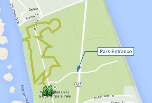
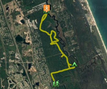
Bella Vista Trail System
The Bella Vista trail system within Washington Oaks Gardens State Park includes the Timucuan hiking trail, Jungle road hike/bike trail and the old a1a hike/bike trail. The 1.7 mile trail explores a mature coastal maritime hammock and borders the edge of a dense canopied coastal scrub. this trail was developed by the Florida department of environmental protection in cooperation with the Florida Trail Association.
Directions
The park is along the west side of A1A, south of Marineland and 4.1 miles north of the Hammock Dunes Bridge at Palm Coast. Drive in on the park entrance road and park by the Bella Vista trail head on the right.
Parking, Picnicking, Rest Rooms, Handicap Access Length 1.7 miles GPS Coordinates: N29°37.9874’ W 081° 12.449’ 6400 N. Oceanshore Blvd. (A1A), Palm Coast, FL 32137 386.446.6780; 8a.m. to sunset, 7 days a week www.floridastateparks.org
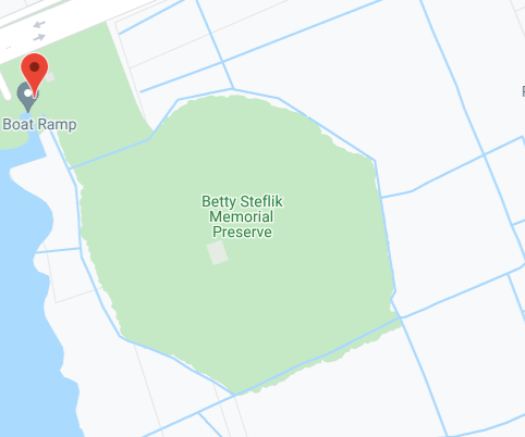
Betty Steflik Preserve Trail
Meandering through the marshes of the Intracoastal Waterway, this nearly 2 mile trail offers a boardwalk section that includes 2 observation decks, a gazebo and covered benches providing a quiet respite for visitors. the sand and shell portion of the trail encircles the park and parking area and is entirely shaded with benches placed along the path to encourage the nature lover to sit and relax. there are three access points to the trail within the 217 acre preserve that is open from dawn until sundown. Boats can be launched from nearby moody Boat launch.
Directions
Parking, Picnicking, Kayaking, Rest Rooms, Handicap Access Length 1.9 miles; boardwalk and unpaved sand/shell GPS Coordinates: 29°28’38.9"N 81°08’08.1"W 815 Moody Lane, Flagler Beach, FL 32136 386.313.4020; Dawn to 11:00 p.m., 7 days a week www.visitflagler.com
Bulow Ruins Trail & Woods Trail
The 150 acres of Bulow plantation ruins stand as a monument to the rise and fall of sugar plantations in east Florida. in 1836, the second Seminole War swept away the prosperous Bulow Plantation where the Bulow family grew sugar cane, cotton, rice and indigo. ruins of the former plantation, a sugar mill, a unique spring house, several wells and the crumbling foundations of the plantation house and slave cabins show how volatile the Florida frontier was in the early 19th century. today, a scenic walking trail leads visitors to the sugar mill ruins, listed on the National register of Historic sites.
Take your pick! 4 mile loop, a 6.8 linear trail, or a 13.4-mile round trip, plus two short nature trails at each end
Directions
From I-95 exit 90, follow Old Dixie Hwy east for 0.9 mile to Old Kings Rd. Drive north 1.9 miles to Bulow Plantation Ruins State Park. Turn right. The trailhead sits just outside the park gate. To Bulow Creek State Park, follow Old Dixie Hwy several miles, passing Walter Boardman Rd before coming to the park entrance on the left. GPS Coordinates: 29.434900, -81.137983
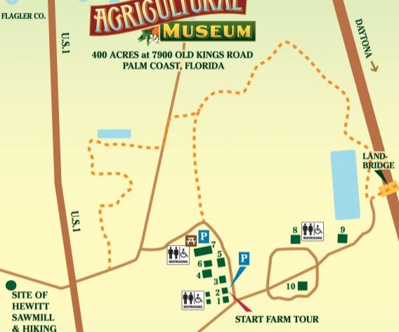
Florida Agricultural Museum & Trails
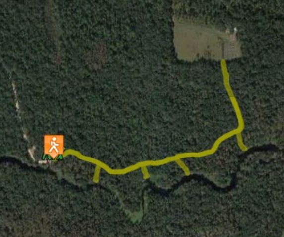
There are approximately 20 miles of trails winding through beautiful forests along Pellicer Creek open for hiking, biking and horseback riding. the trailhead is located at the Caldwell Dairy Barn. The Raymon Tucker Trail leads east via a pedestrian bridge over i-95 to the Princess Place Trails. Guided horseback trail rides and orienteering trails are provided. the Hewitt’s sawmill Trail is a 3/4 mile wooded trail along which there are signs explaining the history of the Sawmill and earthen dam, built circa 1770 to provide lumber to St. Augustine during the Revolutionary War. Picnics can be enjoyed within the covered Caldwell dairy barn. Equestrian camping is available as are guided tours of the museum.
Directions
7900 Old Kings Road, Palm Coast, FL 32137 386-446-7630 GPS Coordinates: 29.642521 -81.28252 Parking, Wednesday through Sunday, 9 a.m. to 5 p.m. Admission charged. Rest Rooms, Handicap Access Length: 3 miles, sand/dirt www.floridaagmuseum.org
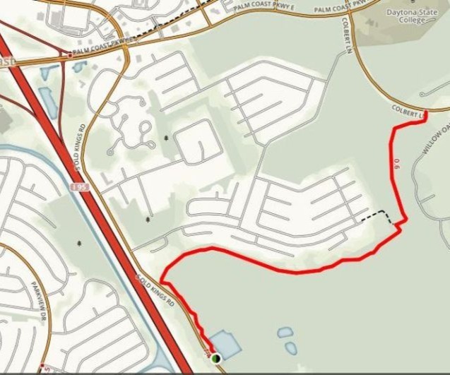
Graham Swamp Northern Trail
Laying at the northernmost end of Graham Swamp this 2.18 mile trail is more visitor-friendly than its southern counterpart, Graham swamp preserve trail. The 10-foot wide coquina trail running east to west between Old Kings Road and Colbert lane. the trail provides an opportunity to experience the unique diversity of wildlife and ecosystems and encourages the use of connecting trail segments and parks.
Directions
Old Kings Road Access To Graham Swamp Trail. Parking, Handicap Access Length 2.18 miles; unpaved coquina shell GPS Coordinates: Latitude: 29.537557 | Longitude: -81.205874 Dawn to Dusk, 7 days a week. Colbert Lane Access from sidewalk to Graham Swamp Trail
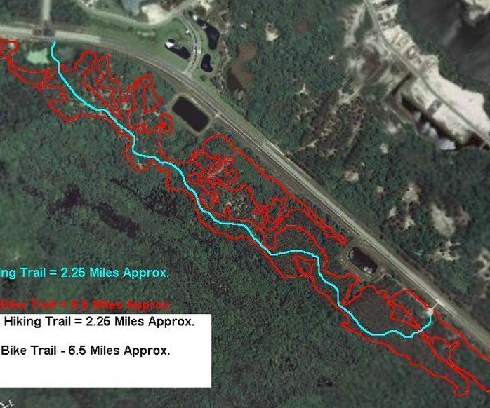
Graham Swamp SE Mountain Bike Trail
This natural and rugged dirt trail lies on the southern end of Graham Swamp winding through heavily wooded terrain for just over 2 miles. The exposed roots, sudden dips and uneven landscape are more for the experienced hiker. A black diamond mountain bike trail, approximately 6.5 miles in length, is also located within the preserve that is home to a rich variety of wading birds and waterfowl as well as deer, otter, fox and other wildlife.
Directions
Parking, Length 6.5 miles; Unpaved, rustic GPS Coordinates: Latitude: 29.508284 | Longitude: -81.161598 access from Colbert Lane, Dawn to Dusk, 7 days a week
Haw Creek Preserve
Tucked away in western Flagler County lies Haw Creek Preserve, a 1,005-acre tract of land bordering Haw Creek for about two miles on its southern boundary. This area was set aside to preserve the cypress oak and hardwood swamp that borders Haw Creek. many Haw trees line the creek and produce the small apple-like fruit from which the creek gets its name. the fruit is popular for making jelly. a winding boardwalk overlooks the creek. launch your canoe, kayak, or boat for a scenic tour or excellent fishing in the dark creek waters. Glimpse an osprey, great blue heron, or anhinga or watch an alligator sunning itself on the bank.
Directions
From the intersection of SR 100 and US 1 in Bunnell, drive west on SR 100 for 7.5 miles to SR 305. Turn left. Drive south on SR 305 for 4.1 miles until you reach CR 2006. Turn right. After 1 mile, turn left on CR 2007, a dirt road, at the large “Russell Landing” sign. Drive 2.2 miles, passing the Pellicer Community Center. The road enters Haw Creek Preserve and ends at a parking area.
Parking, Picnicking, Rest Rooms, Camping, Kayaking, Boating, Handicap Access Length: 1.2 miles, wooden boardwalk GPS Coordinates: 29.395, -81.3823 sunrise to sunset, 7 days a week
Princess Place Preserve Trails
The preserve is the site of the princess estate, a lodge dating back to the late 1800s. there are 16 miles of various hiking and equestrian trails winding through forests of pine, hardwoods and a variety of shrubs and ferns. Hikers can trek along fresh water ponds surrounded by century old live oaks, stroll down a wooden bridge leading to legacy island and an open marsh area or take the rustic trail along pellicer Creek that has 2 observation decks along the way. there are also 4 miles of equestrian trails within the beautifully wooded preserve.
Directions
Parking, Picnicking, Rest Rooms, Camping, Kayaking, Handicap Access Length in total of 8 hiking & 2 equestrian trails – 16 miles; primarily unpaved 2500 Princess Place Road, Palm Coast, FL 32137 7A.M. TO 6P.M. , 7 days a week GPS Coordinates: 29.654,-81.2414
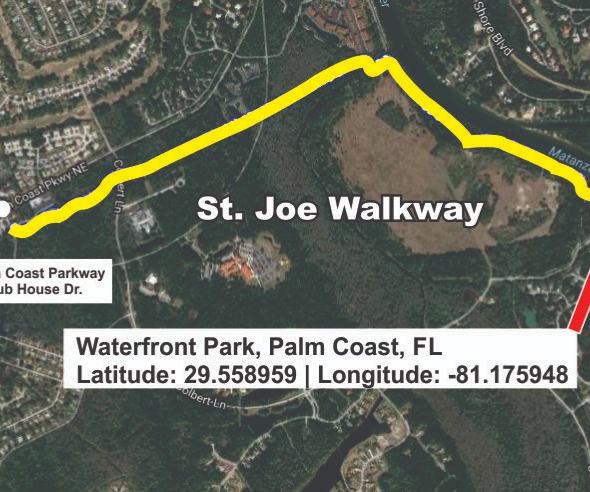
St. Joe Walkway
St. Joe Walkway and bicycle path follows Matanzas River going north from Waterfront park then runs east towards Fire Station 22 located at the intersection of Palm Coast Parkway and Club House Dr. The one-mile length is designated as one of the Great Florida Birding trails and is home to many unique bird species.
Directions
Head South From the intersection of Palm Coast Parkway & Colbert Lane to Waterfront Park Rd. Turn Left on Waterfront Park Rd. Follow Waterfront Park Rd. to the Waterfront Park parking areas. GPS Coordinates: 29.558959, -81.175948
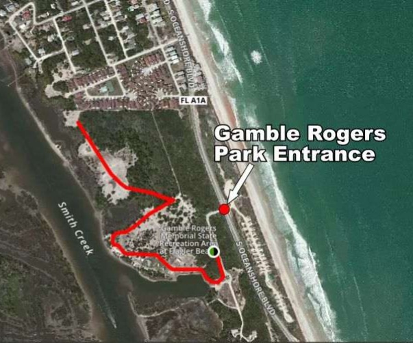
Joe Kenner Nature Trail
Located within the Gamble Rogers Memorial State Recreation Area, this trail is named for Joe Kenner, the Florida Park service’s most gifted interpreter who was an accomplished nature photographer, passionate about manatee conservation as well as the Florida scrub Jay population. the one mile loop winds through a shady coastal forest of scrub oaks and saw palmetto while twists and turns take visitors through ancient dunes and a maritime hammock. The trail is open for hiking only, no bikes.
Directions
Parking, Picnicking, Rest Rooms, Camping, Boating, Handicap Access Length 1 mile, dirt with roots, rocks and low branches GPS Coordinates: Latitude: 29.438904 | Longitude: -81.108633 (A1A), Flagler Beach, FL 32136 386.517.2086; 8 a.m. to sunset, 7 days a week
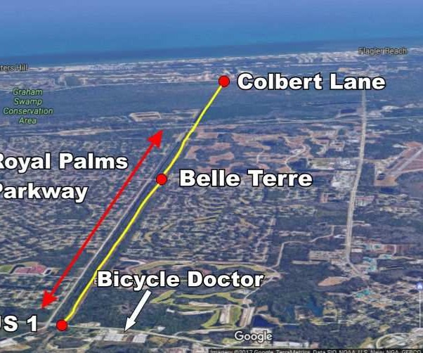
Lehigh Trail
The lehigh trail runs parallel to the lehigh Canal for much of its 8 miles. The west end begins at US 1 just north of Bunnell and travels through Palm Coast ending at Colbert Lane west of the old Lehigh Portland Cement Company. The trail accommodates hikers, bikers and in-line skaters.
Directions
Parking, Handicap Access Length 8 miles, paved asphalt surface GPS Coordinates: (West end, US 1) N 29° 29.956 W -081° 09.476
(East end, Colbert) N 29° 29.774 W -081° 15.855
(Middle with parking Belle Terre) N 29.496619 W -81.219381
Mala Compra Off Road MTB Trail & Greenway Trail
The Mala Compra Off Road Mountain Bike Trail & Greenway is a 323 acre greenway preserving the oak hammock along a1a on the north end of the corridor. Combined with Bings landing and Mala Compra Road/Beachfront Park, the greenway creates an extensive river to sea experience for the visitor. Much of the greenway is adjacent to the bicycle/pedestrian path along A1A. Plantations from the Spanish and territorial periods and middens are within the park.
The Mala Compra technical mountain bike trail accommodates all skill levels.
Directions
Head north on A1A 2.7 miles from the Hammock Dunes Bridge to Bings Landing. Parking, picnicking & rest rooms at Bings landing. Length 5.5 miles of bike trail, sand/dirt GPS Coordinates: Latitude: 29.614991 | Longitude: -81.202589 Dawn to 11 pm 7 days a week